 Albuquerque's Environmental Story
Albuquerque's Environmental Story
Albuquerque's Environmental StoryThirty spokes share the wheel's hub;
It is the center hole that makes it useful.
Shape clay into a vessel;
It is the space within that makes it useful.
Cut doors and windows for a room;
It is the holes which make it useful.
Therefore profit comes from what is there.
Usefulness from what is not there.--Lao Tsu, Tao Te Ching, Ch. 11
translated by Gia Fu Feng
 |
Efforts for the preservation of open space lands began in the 1960s with a few visionary individuals. These early efforts resulted in the purchase of over 7,000 acres of land by 1968. The City Goals Committee wrote in 1969, that the goal is "to preserve the unique natural features of the metropolitan area by achieving a pattern of development and open space respecting the river, land, mesa, mountains, volcanoes, and arroyos." With these words the movement to preserve the features of the city’s natural settings had been given official sanction. Citizens groups were formed to watch over each element of the city’s open space: the Bosque del Rio Grande Nature Preserve Society, Save the Volcanos, Save the Sandias, and Save the Arroyos. In 1975 these groups were brought together under the banner of the citizens Open Space Task Force led by facilitator Philip Tollefsrud. That same year, the City/County Comprehensive Plan was published. The Plan for Major Open Space is one of three volumes of the Comprehensive Plan. It calls for acquisition or public control of the major features of the city’s natural setting. Elected officials and voters got behind the effort to preserve open space.
The city was successful in obtaining all of the five volcanic cones, nearly 4,000 acres on top of the west mesa and volcanic escarpment, a 177-acre nature preserve parcel adjacent to the Rio Grande, and about 1,000 acres in the Sandia foothills. Financing for these acquisitions came largely from land trades, general obligation bonds, federal matching funds, and transfer of federal lands under the Recreation and Public Purposes Act. From 1973 to 1983, not a single local bond issue for open space acquisition failed.
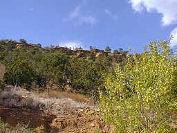
Since the early 1970's, open space advocates had their eye on part of the historic Elena Gallegos grant, an 8,000-acre parcel that comprised one fourth of the city’s Sandia Mountain backdrop. In 1980 talk of developing this land by its owners, the Albuquerque Academy, prompted the city to secure a two-year option to buy the property. The search for federal funding for the $26,000,000 property was unproductive. Finally, near the end of the two-year option period, the U.S. Forest Service offered to trade 18,000 acres of federal surplus land from around the state for the Elena Gallegos grant. The offer was turned down by the Academy. Just before the option expired, a citizen group came forward with a plan to purchase the grant with a local three-year quarter-cent sales tax. The plan also called for the city to trade off the grant land to the Forest Service for the federal surplus lands. Those lands would then be sold by the city, and the proceeds placed in a permanent trust fund for open space management. The plan won the early support of the mayor and the leadership of the City Council. In a massive public campaign, over 15,000 people signed petitions urging the City Council to impose a quarter cent tax, and the grant was purchased in July of 1982. The city retained a 640-acre mountain park site in the grant and traded over 7,000 acres to the Forest Service. The 640 acre mountain park is now the site of the Elena Gallegos Picnic area/Albert G. Simms Park.
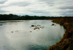
The Open Space Trust Fund provided a means by which other city open space areas could be managed and developed for appropriate recreational use. Several proposals had been advanced to manage the Rio Grande and bosque (river forest) as a nature preserve and recreation area. In 1983 city officials gave staff the go ahead to approach the state legislature to authorize creation of Rio Grande Valley State Park to be managed by the city. The bill authorizing the park passed unanimously in both houses of the legislature and was signed into law by the governor in March 1983. The Rio Grande Valley State Park embraces a 23-mile section of the river running through the heart of Albuquerque. Facilities include trails, picnic areas, and access points with plans for rafting and canoe launch areas.
Rex Funk, for many years chairman and moving spirit of the Open Space Task Force, had played a major role in the acquisition of the Elena Gallegos area and the creation of the Rio Grande Valley State Park. Mr. Funk became the first director of the Open Space Division which was created in 1984.
The creation of the Open Space Division allowed for personnel to properly manage and maintain Open Space lands. Three sections were formed within the Division: Operations and Maintenance, Law Enforcement and Visitor Services. The Operations and Maintenance section is charged with the responsibility of overseeing all park maintenance needs, including fencing, trail work, and building upkeep. The Operations section now employs 10 permanent employees plus three temporary positions. The Law Enforcement section was added to the Division in 1986. Law enforcement officers are fully commissioned police officers who ensure the protection of the natural and archaeological resources within Open Space Division managed lands. This section now holds 13 positions, including one chief and three sergeants. The Visitor Services section was added to the division in 1989. With this addition, several programs are now offered to raise awareness and educate people about the environment, and the Open Space Program. Visitor Services has 4 permanent and 8 temporary employees.
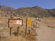
In the early 1990's, the city’s Open Space Division joined forces with the National Park Service to manage the Petroglyph National Monument. The city had already acquired land along the petroglyph-rich volcanic escarpment, and had approved the NW Mesa Escarpment Plan to protect the area and its rock art. The combined resources of the city, state, and federal government are now at work acquiring and managing these important lands, Over 15,000 petroglyphs and a 1000-room adobe pueblo site are protected by these joint efforts.
After a long planning effort that included extensive monitoring of vegetation and wildlife, the Bosque Action Plan was approved by the city, state and county in 1993. This allowed the various agencies involved in managing the bosque to work together with defined guidelines for preservation. Environmental education programs include the summer Fireside Chat Series, guided hikes, interpretive tours for school groups, service learning projects, and teacher workshops. The Trail Watch Volunteer Program was instituted in 1994. Trail Watch Volunteers are regular hikers in open space areas that serve as extra eyes and ears for the Division. In 1996, a non-profit group the Open Space Alliance (OSA), was formed, This allowed the Division to receive additional support, such as the Community Interpreters Of The Environment program, (C.I.O.T.E.). These are volunteers who are trained to assist with leading environment education programs. Additionally, the OSA has contributed with volunteer trail maintenance and clean-up projects. 1996 also saw the addition of working with another not-for profit group called the Rio Grande Community farms (RGCF). This group takes care of the farming of two agricultural areas in the North Valley owned and managed by the Open Space Division, Candelaria Farms and Los Poblanos Farms. The sustainable agricultural methods used by RGCF help to preserve wildlife habitat for the migratory bird population that is prominent in the North valley of Albuquerque where the land is located. Education programs, service learning projects and demonstration gardens are all part of the activities that take place at both farms. All farming methods are organic.
In 1997, Citizens once again approved a 1/4 cent tax increase that will be
in effect from 1998-2000. The tax will raise approximately $32 million dollars
to purchase over 9,600 acres of land proposed as major public Open Space. Two
properties that were acquired in 1998 include Los Poblanos Farms (formerly know
as Anderson Fields), and Tres Pistolas. Other projects that are in the works
include the construction of a handicap accessible trail at the Elena Gallegos,
and the opening of an interpretive center near the Piedra Marcadas pueblo in
the year 2000.

"I am glad I shall never be young without wild country to be young in. Of what avail are forty freedoms without a blank spot on the map?"--Aldo Leopold, the first secretary of the Albuquerque Chamber of Commerce and one of the city's first open space advocates.
|
LOCATION |
ACREAGE |
|
WEST SIDE |
|
|
Shootong Range |
3832 |
|
Volcanoes |
4209 |
|
West Mesa |
3650.7 |
|
La Boca Negra Park |
1527.6 |
|
Piedras Marcades |
792.7 |
|
Total - 14,012 |
|
|
BOSQUE / VALLEY |
|
|
Rio Grande State Park |
5,215.50 |
|
Candelaria Farm |
176 |
|
Roberson Ranch |
26.5 |
|
Blanchard |
20 |
|
Alameda |
8.5 |
|
Anderson Field |
138 |
|
Total - 5,584.5 |
|
|
ARROYOS |
|
|
Montessa Park |
577 |
|
Bear Canyon |
114.5 |
|
Pino Arroyo |
18 |
|
Total - 709.5 |
|
|
SANDIA FOOTHILLS |
|
|
Foothills |
1059.2 |
|
Elena Gallegos |
640 |
|
Rounds Estate |
324 |
|
Four Hills |
186 |
|
2,209.20 |
|
|
EAST MOUNTAINS |
|
|
Sedillo / Juan Tomas |
1455 |
|
Golden |
1180.3 |
|
Placitas |
560 |
|
Gutierrez Canyon |
300.6 |
|
San Antonio |
168.5 |
|
Tres Pistolas |
106 |
|
Carolino Canyon |
27.5 |
|
Total - 3,797.9 |
|
|
Aggregate Total - 26,313.1 |
|
(Up to Section V, Back to Occupational Health, On to Physical Accessibility)