 Albuquerque's Environmental Story
Albuquerque's Environmental Story
Albuquerque's Environmental Story 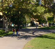 |
In many ways, the story of Albuquerque's public park system also tells the history of Albuquerque's growth from a tiny Spanish village in the 1700s to a community of half a million people approaching the 21st century. That story includes key political figures, federal funding programs, recreation trends, and the growth of neighborhood and citizen involvement. The City of Albuquerque's goal is to provide facilities and programs so that citizens may enjoy pleasurable leisure time
Public interest in parks goes back two centuries to the time when Old Town Plaza was the city's first meeting place. After the coming of the railroad in the 1880s, other parks, including Robinson Park, at Eighth and Central, were built before the turn of the century. The early 1900s brought McClellan and Highland Parks in the downtown area. Rio Grande Park came into being through the vision of Aldo Leopold, who advanced the idea of a park along the river for all the people. The park, built in the 1920s, extended to the river's edge. In 1927, the city's small zoo was moved from Broadway and Tijeras to Rio Grande Park. The zoo has now taken over most of the original park area.
During the Great Depression of the 1930s, federal WPA (Works Progress Administration) and NYA (National Youth Administration) aid went into substantial projects such as the construction of Roosevelt Park, Heights Community Center, Barelas Community Center, and the original Tingley (baseball) Field. This was the first time that Mayor Clyde Tingley, an important political figure of early Albuquerque, gave his name to public facilities. Tingley was also involved in the planting of elm trees along Silver Avenue SE near the University and Presbyterian Hospital. Two tennis courts were built at Wellesley and Coal SE. Eight courts, built at Rio Grande Park, now lie under the parking lot of the Zoo. Walls of stone are symbolic of that period and can still be seen at Roosevelt and Wellesley.
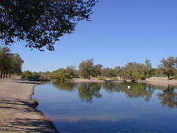
The Middle Rio Grande Conservancy District was formed in the 1930s to combat the annual valley and downtown flooding of the Rio Grande. This agency built miles of flood control levees and a lagoon, just south of Central. This became Tingley Beach, the city's first public swimming area. The polio epidemic of the early 1950s closed the beach to swimming, but fishing has continued. As the city grew after WW II, a few other parks (Hyder, Bataan) were built, but little money was invested before the housing boom that started in the mid-1950s.
The city was then growing rapidly, and the need arose for an organizational unit to take care of the various activities and to recommend expansion of facilities. The Parks and Recreation Board began its work in 1953. In the summer of 1954, a director was chosen and assumed charge of planning and administration. One of the first items of business was to develop a park dedication policy to ensure future park land. The Parks and Recreation Board and its new director formulated the policy with the assistance of home builders.
From 1955 through 1976, the City Park Dedication ordinance required dedication of park land based on the amount of land being subdivided by the home builders (developers.) Land was often accepted sight unseen. Many subdivisions of the 1950s and early 1960s gave small park tracts containing arroyos. Many of these small parks weren't centrally located within the neighborhood. The park policy was changed in 1976, and now requires land dedication based on the number of dwelling units being developed. The home builder must also pay a fee to help speed development of neighborhood parks.
In 1993 the state legislature authorized the Development Fee Act. This act allows municipalities and counties statewide and authorized local government to charge a fee that helps pay for the impact of new homes on the community. In contrast to previous park ordinances, which covered only parks, fees can now be collected for a variety of recreation facilities including trails, pools, and tennis courts. As this article is being written, the city council discussion has not yet decided the level of fee that will affect only new residential construction and not the sale of existing homes.
In 1953 the city had 30 developed park and recreation areas ranging in size from very small, ornamental plots to more than 60 acres. Total acreage at that time was 185 acres. In 1964, the area had grown to 475 acres and by 1984, there were 791 acres of city park land developed and 343 acres undeveloped. In the mid-nineties, the total is more than 200 developed parks, representing 1500 acres of developed park land and 450 acres of undeveloped parks.
A landmark agreement that provides for cooperation between the city and the Board of Education was the 1964 Joint Use Agreement. In some neighborhoods lacking park land, the city leased undeveloped school playgrounds and built a variety of park and recreation improvements. The city may also use public school buildings and grounds for recreation programs. In exchange, the interscholastic public school athletic program uses city swimming pools, tennis courts, baseball and softball fields for practice and games As of 1995, there are more than 30 such agreements.
Another significant partnership is with the Albuquerque Metropolitan Flood Control Authority (AMAFCA). AMAFCA has allowed multiple use of their land which holds flood control facilities for additional park uses such as golf courses, recreation trails and soccer fields.
Equitable distribution of park land and facilities to serve each geographic area is a city goal. Some of the criteria applied to achieve a balanced distribution are population, transportation, access and cost effectiveness of facility usage.
 |
The 1976 Comprehensive Plan set goals that include (1) park facilities within one-half mile of every neighborhood (2) development of parks on school grounds and (3) area planning for parks to serve several neighborhoods. The city's planning policy that led to "sector planning" for large areas enabled the park system to select better, more centralized locations for neighborhood parks and also acquire larger sites.
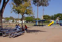
A park system issue current in the mid-nineties is the inadequate number of larger (minimum 10 acres) nonresidential area parks. Land dedication through the subdivision process served only the purpose of providing neighborhood parks 2-10 acres in size, usually. Larger parks had to be purchased using the capital improvements process and bond issues. These typically provided only construction and not land acquisition; thus most of Albuquerque's parks are small. This lack of large parks has forced use of small (2-10 acres) neighborhood parks for youth athletic fields. The tremendous popularity of youth soccer has resulted in overuse of neighborhood parks as athletic fields. One possible solution, making these parks "off limits," would mean severe limitations on youth programs.
Since 1980, citizens, elected officials, and planners have focused on the need for larger parks, and tracts amounting to more than 100 acres have been acquired. One reason for concentrating development in larger parks is that development and operating costs per acre are more cost effective. For example, less employee time is spent in nonproductive driving to and from parks and handling equipment. And community parks accommodate softball, soccer, and football teams. as well as large community gatherings and festivals.
Another significant policy affecting the park system has been the water conservation policy of 1994. A goal of water reduction was established by the city council to reflect the realities of maintaining turf in a semi-arid environment. Our community, as a whole, must decide whether we should acquire as much land as possible or have more small parks.
 |
Additionally, the park system includes street beautification, environmental awareness, and urban enhancement through unique, landscaped areas within the urban area. The beautification of streets and public rights-of-way was expanded because of the Urban Enhancement Trust Fund established in 1981. Also in 1989, the Transportation General Obligation bond purpose was expanded to include 1% for landscaping. Many arterial collector streets are landscaped, including Lomas, Central, Coors, and Louisiana. Other neighborhood dividers--San Pasqual Ridgecrest, Silver SE--are landscaped.
Most parks, street greens and landscaped dividers, no matter how small, possess open space value. The landscaped space may be used to picnic or just to sit. Street medians, too small for a person to sit within, still offer the value of an improved landscape area in contrast to the street.
There are many reasons for the existence of parks of all sizes and shapes. Parks improve cities. They complement the city and add a good dimension to the urban environment. They attract wildlife, preserve biological, ecological, and geographical features, prevent wind and water erosion, increase humidity--especially in arid areas--create aesthetic advantages (visual screening and visual contrast), architectural change, ornamental and recreational advantages, reduction of stress, a sense of space, contact with nature and opportunity to study flora and fauna, preservation of items of cultural and historical importance, and the sharing of spaces between different parts of the city. Parks can be used as connecting or separating spaces. They can direct traffic flow and use undeveloped land to beautify and increase property values.
Our challenge, in planning for the future, is to locate parks in places that will best serve and take into consideration both human need and the resources of nature.
(Up to Section V, Back to Art in Public Places, On to Cultural Diversity)