 Albuquerque's Environmental Story
Albuquerque's Environmental Story
Albuquerque's Environmental StoryAlbuquerque is a unique place in many ways. One contributing element is the natural drainage system of arroyos. These arroyos carry runoff from the Sandias and West Mesa to the Rio Grande and are dry most of the year. They flow most heavily in the summer when the warm, moist, tropical air masses from southern California and the Gulf of Mexico collide over the Sandias. Originally these arroyos meandered freely across the land responding to the volume and velocity of storm water runoff, thereby creating large flood plains and alluvial fans.
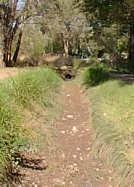
Natural arroyos are rich in plant life due to the soil moisture that remains after runoff events. Dense growths of chamisa, Apache plume, skunkbush, and even a few cattails line arroyo channels. Herbs and grasses often are quite healthy along these channels also. The abundant vegetation attracts a concentration of native wildlife in search of food and shelter. Herbivores like the jackrabbit, cottontail, rock squirrel, white-tailed antelope, ground squirrel, pocket gopher, flocks of sparrows, towhees, and other birds flock to natural arroyos. Predators like the coyote, badger, hawk, owl, roadrunner, and a variety of snakes and lizards also frequent natural arroyos. Bears, deer, and mountain lions use arroyo channels as migratory routes. With such a diversity of plants and wildlife, it would seem that urban residents would be eager to preserve arroyo flood plains. This, unfortunately, has not been the case. Only a few sections of arroyos have been preserved as natural channels in the Albuquerque metropolitan area.
A good example of a natural arroyo corridor is the Bear Arroyo north of Montgomery, between Juan Tabo and the Sandia Foothills. Over 150 acres in this area are preserved as natural channel. Hiking trails run through the area, and visitors delight at the wildlife and vegetation. The trails link with foothill and mountain trails of the Sandias. A 1% for art sculpture of a mother bear with two cubs graces a granite boulder at the Bear Arroyo and Tramway.
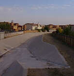
Although residents discovered the natural and recreational virtues of arroyos late, a 1986 document entitled the Facility Plan for Arroyos has attempted to make up for this oversight. The plan recognizes three classifications of arroyos in the metropolitan area. The first of these is Urban Recreational Links. These are located in highly developed or developing urban areas. They have usually been straightened and concrete lined, but some contain linear park sections. Examples include much of the Embudo and Bear, Hahn, and lower Piedras Marcadas Arroyos. They can accommodate trails and some active recreation.
 |
The second category is the Open Space Link Arroyos. These channels have the potential to link major Open Space areas such as the Sandia Foothills, Bosque, and West Mesa Open Space. Examples include Piedras Marcadas, South Pino, Amole, Pajarito, and La Cueva Arroyos. Prescribed treatments can include hard lining, rip-rap, or other channel treatments. The third category is Open Space Arroyos. The plan mandates that these arroyos be maintained as natural channels wherever possible. The Callabacillas and portions of the Tijeras Arroyos and parts of some other arroyos fit into this category. The Tijeras is the largest, and the Callabacillas is the second largest arroyo in the metropolitan area. The Tijeras Arroyo, which flows out of Tijeras Canyon south of the Albuquerque International Airport and empties into the Rio Grande south of Rio Bravo, drains over 80 square miles and has a 100-year-storm capacity two-thirds that of the Rio Grande. The Arroyo Facility Plan mandates that Open Space arroyos will be maintained in their natural state with little or no structural improvement. Encroachment into the flood plain and channelization is to be prevented by public acquisition of the natural flood plain through dedication or purchase. The Arroyos Facilities Plan also proposes a network of connecting trails along arroyos so that residents can enjoy off-street walking, cycling, and horseback riding.
Implementation of this plan will require public education, advanced planning, coordination, and public expenditure. It is a reversal of years of seeing and using arroyos for only the purpose of carrying storm runoff. Some gains have already been made in trail construction, and preserving sections of arroyos like the Bear and upper San Antonio in natural channels. Recreation trail planning is complete for some arroyos, but funding will be required to implement the plans. Rapid development and accompanying runoff is threatening encroachment on the Calabacillas and Tijeras Open Space Arroyos, and motorized vehicles and trash dumping is degrading these natural areas. Owners of private lands along these arroyos would like to build as close to the channel as possible, and sometimes propose channelizing the arroyo. The Arroyo Facilities Plan is the first balanced attempt to look at multiple use of the arroyo system. With intense development, there will be pressure to ignore the plan in favor of "business as usual." Open Space arroyos need to be consolidated in public ownership and managed under the Open Space system if they are to be preserved. Only strong public advocacy will prevent the loss of these last natural arroyo systems.
 |
Development increases the amount of runoff into channels by increasing the area of impervious surface. With increased urbanization some kind of channel treatment is necessary, not only because the increased runoff causes problems, but because the channels can be hazardous. Given the pattern of brief, but intense, summer storms, there is danger associated with arroyos. A person in one part of an arroyo can be unaware of precipitation at its head, and can be taken by surprise by a debris-laden wave. Just a few inches of fast-moving water in a channel can cause a person to lose footing. The safest time to venture into an arroyo is when the skies are cloudless and blue, but it is important to remember that good weather is never a guarantee of safety, as many banks are weakened by erosion and tend to crumble.
There are many different ways of treating arroyos to reduce hazards and allow development. Each has its advantages and disadvantages, depending on economics and adjacent land uses. Density of development, amount of impervious surface, and the character of development are three elements of adjacent land use that must be understood before selecting an arroyo treatment. These elements are intertwined, but analyzing each separately makes it possible to arrive at the best possible solution. For example, an area with large impervious surface, high density, and a population usually present only from 9 to 5 may be best suited to a concrete-lined channel. On the other hand, a residential area with low density and a small area of impervious surface might be best handled by an open space plan.
Traditionally, engineers have used concrete channels to move storm water runoff through the drainage system as efficiently and quickly as possible. But environmentalists have wanted to slow the water and treat arroyos as an amenity and resource. These citizens favor allowing infiltration and nurturing of native plants, thereby creating open space parks along the sides of the natural arroyos. By analyzing adjacent development and considering the entire length of the arroyo as a system, the ideas of both engineers and environmentalists can be realized.
Albuquerque currently treats arroyos in seven different ways, depending on times and places in which each treatment may be appropriate. Analyzing characteristics is difficult, but must be done to arrive at the appropriate treatment.
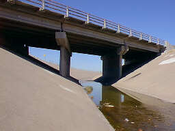 |
Some other problems of concrete lined channels involve erosion and sediment. In many places the channels do bend or are narrowed, as, for example, in culverts under roads. This causes water velocity to decrease. As the flow slows, particles drop from the water and produce sediment build up which can clog the system. Concrete channels need maintenance to remove this sediment. Erosion becomes a problem when an upstream section of the arroyo is concrete lined and it meets a downstream, unlined section. The increased velocity of the water flowing from the lined channel immediately erodes the unlined section. Conversely, an unlined section upstream can bring sedimentation into a lined section. When selecting a treatment for a section of arroyo channel, it is important to be aware of what is occurring both upstream and downstream.
Storm sewers that replace arroyos with an underground pipe system entirely alter the landscape. However, storm sewers allow the freedom from planning for an on-site arroyo, and the initial construction cost can be outweighed by the value of land gained. Although land can be saved, the maintenance cost of this closed system can be high.
During heavy flows, the water can back up and have nowhere to go. The system does leave land free for development, but its use would take away an element that makes Albuquerque unique.
(Up to Section V, Back to Architectural Review, On to Art in Public Places)